

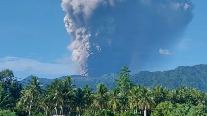
A massive eruption at Mount Dukono has left three hikers dead and triggered a major rescue operation in eastern Indonesia after the volcano blasted a towering ash plume nearly 10 kilometers into the sky.
The eruption, which occurred on Friday morning on Indonesia’s remote Halmahera Island, sent shockwaves through nearby communities as thick grey ash clouds spread across parts of North Maluku Province. Authorities say around 20 hikers were near the volcano when the eruption struck, despite an existing exclusion zone around the crater.
The disaster is once again drawing attention to Indonesia’s volatile volcanic geography and the risks surrounding one of the world’s most active volcano systems.
Where is Mount Dukono?
Mount Dukono is located on Halmahera, the largest island in Indonesia’s Maluku archipelago in the country’s eastern region.
The volcano sits within the following:
- North Maluku province
- Eastern Indonesia
- The Pacific Ring of Fire
Halmahera lies between the following:
- Sulawesi
- Papua
The region is known for:
- Dense tropical rainforest
- Frequent earthquakes
- Active volcanoes
- Rugged mountain terrain
Why does Indonesia have so many volcanoes
Indonesia sits atop major tectonic plate boundaries where the Indo-Australian, Pacific, and Eurasian plates interact.
That geological position makes the country
- One of the world’s most earthquake-prone nations
- Home to nearly 130 active volcanoes
- A central part of the Pacific “Ring of Fire.”
Consider adding a regional map graphic here showing:
- Halmahera island
- Mount Dukono’s location
- The wider Pacific Ring of Fire zone
What happened during the Mount Dukono eruption?
According to Indonesia’s volcanology agency, the eruption occurred at approximately 7:41 a.m. local time on Friday.
What witnesses saw
Officials reported:
- A loud booming explosion
- Thick grey ash clouds
- A volcanic ash column rising nearly 10 kilometers high
- Ash drifting toward populated northern areas
The eruption quickly triggered emergency rescue operations after hikers near the crater were reported stranded.
Casualties confirmed
Authorities say three hikers died:
- Two from Singapore
- One Indonesian national
Police and rescue officials stated the hikers had entered a restricted zone near the crater despite official warnings already being in place.
Why Mount Dukono is considered extremely dangerous
Mount Dukono is not an occasional volcano. It is one of Indonesia’s most persistently active volcanic systems.
Erupting almost continuously since 1933
The volcano has experienced near-continuous eruptive activity for more than 90 years.
It frequently releases the following:
- Volcanic ash
- Sulphur dioxide gas
- Explosive eruptions
- Falling rock and debris
That ongoing activity regularly affects:
- Nearby villages
- Air quality
- Aviation routes
Indonesia’s geology agency had already expanded restrictions around the crater on April 17 after detecting increased volcanic activity.
Authorities specifically banned access within a four-kilometer radius of the crater.
A useful infographic here could show:
- Indonesia’s volcano alert scale
- Mount Dukono’s current alert status
- Hazard zones around the crater
Rescue teams race through dangerous terrain
The eruption triggered an urgent search-and-rescue mission involving:
- Disaster response teams
- Local police
- Emergency rescuers
- Medical evacuation crews
Difficult conditions slowing rescue efforts
Officials say rescue operations are complicated by:
- Steep volcanic slopes
- Thick ash deposits
- Reduced visibility
- Falling volcanic debris
Some stranded hikers may require stretcher evacuation due to dangerous terrain coated in volcanic ash.
According to local authorities:
- Around 20 hikers were initially caught near the slopes
- Fifteen had safely descended several hours later
- Search operations remained ongoing Friday
Why volcanic ash can be so dangerous
The dramatic ash cloud may look visually spectacular, but volcanic ash is highly hazardous.
Risks from volcanic ash exposure
Ash particles can:
- Damage to the lungs and airways
- Reduce visibility to near zero
- Contaminate water supplies
- Damage engines and aircraft
- The trigger roof collapses during heavy accumulation
Officials warned that rainfall could worsen conditions by creating volcanic mudflows known as lahars.
These fast-moving flows can carry the following:
- Ash
- Rocks
- Mud
- Tree debris
down mountain slopes with devastating force.
Ash cloud drifting toward populated areas
Authorities warned that ash from the eruption was moving north toward inhabited districts, including Tobelo.
Residents were advised to:
- Stay indoors when possible
- Wear masks outdoors
- Avoid areas near river channels
- Monitor official emergency updates
Potential disruptions include:
- Flight delays
- Reduced air quality
- School and transportation interruptions
Why Indonesia remains one of the world’s most volcanically active countries
Indonesia experiences frequent volcanic eruptions because of its unique geology.
The country’s location along tectonic plate boundaries creates the following:
- Constant seismic pressure
- Magma movement beneath the surface
- Frequent volcanic instability
Some of the world’s deadliest eruptions have occurred in Indonesia, including:
- 1883 eruption of Krakatoa
- 1815 eruption of Mount Tambora
Mount Dukono may not be as globally famous, but volcanologists consider it one of the country’s most consistently active threats.
TL;DR
- Mount Dukono erupted Friday on Halmahera island in eastern Indonesia
- The volcano sent ash nearly 10 kilometers into the sky
- Three hikers died after entering a restricted zone near the crater
- Rescue crews are searching for stranded hikers in hazardous conditions
- Officials warned of ash rain, mudflows, and further eruptions