
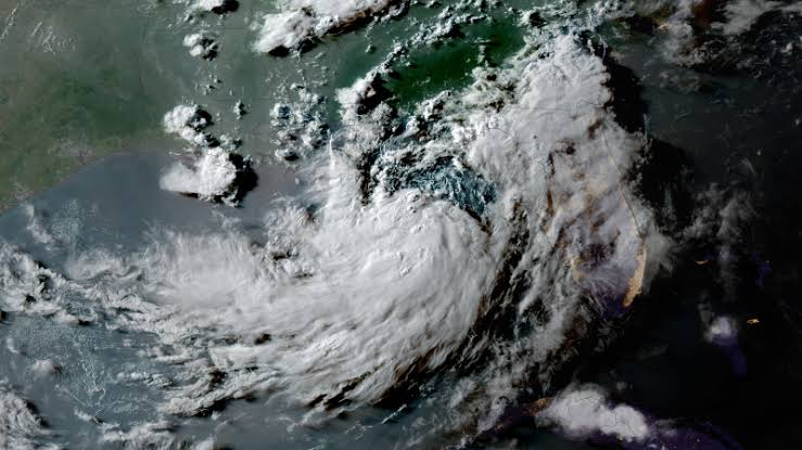
Tropical Storm Bertha is strengthening in the Gulf of Mexico as it slowly tracks toward the northern Gulf Coast, prompting tropical storm and storm surge alerts across parts of Florida, Alabama, Mississippi, and Louisiana.
The National Hurricane Center (NHC) warns that Bertha could bring damaging winds, life-threatening storm surge, torrential rainfall, flash flooding, and isolated tornadoes over the coming days. Residents along the Gulf Coast are being urged to monitor official forecasts as the storm’s slow movement could prolong hazardous conditions.
Where Is Tropical Storm Bertha Now?
As of the latest advisory from the National Hurricane Center, Bertha is located about 125 miles (205 kilometers) south of Panama City, Florida.
The storm has maximum sustained winds of approximately 50 mph (85 km/h) and is moving slowly toward the northwest. Forecasters say additional strengthening is possible before the system approaches the northern Gulf Coast.
Where Is a Tropical Storm Warning in Effect?
A Tropical Storm Warning means tropical storm-force winds are expected within the warning area, generally within 36 hours.
According to the National Hurricane Center, the warning currently extends:
- From the Alabama–Florida border.
- Westward to the Jefferson/Plaquemines Parish border in Louisiana.
Communities within the warning area could experience:
- Sustained tropical storm-force winds.
- Heavy rainfall.
- Downed trees and power outages.
- Dangerous coastal conditions.
Where Is a Tropical Storm Watch in Effect?
A Tropical Storm Watch means tropical storm conditions are possible, typically within 48 hours.
Current watch areas include:
- Metropolitan New Orleans.
- Areas west of the Jefferson/Plaquemines Parish border to Morgan City, Louisiana.
- Parts of Florida’s Panhandle, including Panama City and nearby coastal communities.
Where Is a Storm Surge Watch in Effect?
A Storm Surge Watch has been issued for:
- The Alabama–Florida border.
- Westward to the mouth of the Mississippi River.
Storm surge occurs when strong winds push seawater inland, causing coastal flooding that can become life-threatening.
Forecasters warn that surge levels of 2 to 4 feet above normally dry ground are possible in some coastal areas, depending on the storm’s exact track and intensity.
What Impacts Are Expected?
Bertha is forecast to bring multiple hazards across the Gulf Coast.
Heavy Rainfall
Several areas from the Florida Panhandle through southeastern Louisiana could receive several inches of rainfall, with localized higher totals capable of producing:
- Flash flooding.
- Urban flooding.
- Rising rivers and streams.
Slow-moving tropical systems often increase the flood risk because heavy rain persists over the same locations for an extended period.
Strong Winds
Tropical storm-force winds may:
- Damage trees.
- Cause scattered power outages.
- Produce hazardous conditions for travel.
- Create dangerous marine conditions.
Additional strengthening remains possible before landfall.
Coastal Flooding and Dangerous Seas
Large waves, rough surf, and dangerous rip currents are expected along much of the northern Gulf Coast.
Boaters are advised to remain in port as seas become increasingly hazardous. Coastal flooding may worsen around high tide.
Isolated Tornadoes
Forecasters also warn that rainbands associated with tropical storms can produce brief tornadoes, particularly after the storm begins moving inland.
What Should Residents Do?
People living in areas under watches or warnings should:
- Monitor updates from the National Hurricane Center and local National Weather Service offices.
- Follow evacuation or emergency guidance issued by local officials.
- Prepare emergency supplies, including food, water, medications, and flashlights.
- Avoid flooded roads and coastal waters.
- Secure outdoor furniture and loose objects before strong winds arrive.
Because Bertha is moving slowly, impacts could continue even after the storm reaches the coast.
The Bottom Line
Tropical Storm Bertha continues to strengthen over the Gulf of Mexico and is expected to bring heavy rain, strong winds, storm surge, and coastal flooding to portions of the northern Gulf Coast. Tropical Storm Warnings cover areas from the Alabama–Florida border into southeastern Louisiana, while Storm Surge Watches remain in effect along vulnerable coastal sections.
Residents should continue following official forecasts, as even small changes in Bertha’s track could significantly alter where the strongest winds, heaviest rainfall, and highest storm surge occur.
TL;DR
- Tropical Storm Bertha is strengthening over the Gulf of Mexico.
- Tropical Storm Warnings are in effect from the Alabama–Florida border westward to southeastern Louisiana.
- Tropical Storm Watches extend farther west into Louisiana and parts of the Florida Panhandle.
- A Storm Surge Watch is in effect from the Alabama–Florida border to the mouth of the Mississippi River.
- Heavy rain, coastal flooding, damaging winds, and isolated tornadoes are possible across portions of the Gulf Coast.