

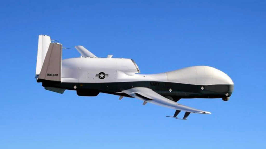
A high-end US Navy drone didn’t just pass by Cuba this week—it lingered, watched, and mapped. The aircraft, an MQ-4C Triton with the callsign BLKCAT6, spent hours tracing Cuba’s coastline and hovering over key maritime routes. That’s not routine. And in the current geopolitical climate, it’s unlikely to be accidental.
This wasn’t surveillance in the shadows. Flight-tracking data shows the drone’s path was visible in near-real time, suggesting the mission may have been designed not just to gather intelligence but to send a message.
What Happened Off Cuba’s Coast?
The MQ-4C Triton conducted a prolonged surveillance mission along Cuba’s northern coastline before shifting southward. It then focused on the Jamaica Channel—a roughly 200-kilometer-wide maritime corridor that connects the Panama Canal to the Atlantic Ocean.
This route matters. It’s a vital artery for global shipping, particularly for energy flows.
Key observations from the mission:
- The drone loitered near Havana for hours.
- It moved deliberately toward a strategic chokepoint.
- Its flight path was publicly trackable, not concealed.
That last detail stands out. High-value surveillance missions are often masked. This one wasn’t.
What Is the MQ-4C Triton and Why Is It So Valuable?
The MQ-4C Triton isn’t just another drone. It’s among the most advanced maritime surveillance platforms in the world.
Core capabilities:
- Altitude: Operates above 50,000 feet
- Endurance: Over 24 hours in a single mission
- Range: Up to 7,400 nautical miles
- Cost: Around $200–240 million per unit
What makes it unique:
- Designed for persistent surveillance over vast ocean areas
- Equipped with sensors to track ships, signals, and surface activity
- Works alongside P-8A Poseidon aircraft to create a layered intelligence network
Think of it as a high-altitude, long-duration eye in the sky—one that doesn’t blink.
Why the Jamaica Channel Matters More Than It Seems
The Jamaica Channel isn’t widely discussed outside defense circles, but it’s critical.
Why it matters:
- Connects the Panama Canal to Atlantic trade routes
- Used by oil tankers and cargo vessels
- Serves as a gateway between the Caribbean and global markets
Control—or even just surveillance—of such chokepoints has always been central to global power dynamics.
The bigger picture:
The US has long monitored strategic maritime corridors. But today, the stakes are higher due to:
- China’s dependence on seaborne energy imports
- Increasing geopolitical friction across multiple regions
- The vulnerability of narrow shipping routes
From Southeast Asia to the Middle East and now the Caribbean, these chokepoints form a global network of strategic pressure points.
Is This About Cuba or Something Bigger?
At first glance, the mission appears focused on Cuba. But zoom out, and a broader pattern emerges.
A wider geopolitical map:
- Venezuela: Energy reserves and political alignment
- Iran: Control over the Strait of Hormuz
- Southeast Asia: South China Sea tensions
These regions share one thing: proximity to critical trade and energy routes.
The Caribbean fits into this framework as another node—one that can influence Atlantic shipping flows.
What this suggests:
- The US may be reinforcing surveillance coverage across global chokepoints
- The mission could be part of a coordinated strategy, not a standalone event
- Visibility of the drone may have been intentional
In short, this wasn’t just about watching—it may have been about being seen watching.
How Does the Triton Compare to Other Military Drones?
Understanding the Triton’s role becomes clearer when compared to other platforms.
MQ-4C Triton vs MQ-9 Reaper:
| Feature | MQ-4C Triton | MQ-9 Reaper |
|---|---|---|
| Primary Role | Maritime surveillance | Combat/strike missions |
| Endurance | 24+ hours | ~27 hours |
| Altitude | High-altitude (50,000+ ft) | Medium-altitude |
| Weaponized | No | Yes |
| Coverage Area | Vast ocean regions | Tactical battlefield zones |
The Triton is not designed to strike—it’s built to observe, track, and inform.
What About the E-2D Hawkeye?
Another key asset in the US Navy’s arsenal is the E-2D Hawkeye, often deployed in tandem with surveillance systems.
What it does:
- Detects low-flying threats using advanced radar
- Acts as a command-and-control hub
- Coordinates between air, sea, and ground forces
While the Triton gathers wide-area intelligence, the Hawkeye helps interpret and act on it in real time.
A Recent Incident Raises More Questions
This mission comes just days after another MQ-4C Triton reportedly went “missing” over the Persian Gulf following a short surveillance operation.
Context:
- The incident occurred shortly after a US-Iran cease-fire.
- Iran had agreed to reopen the Strait of Hormuz
- The drone had been monitoring the region for about three hours
The timing is notable. It underscores how sensitive—and risky—these surveillance missions can be.
Why Make the Mission Publicly Visible?
This may be the most telling detail.
If the US wanted to hide the mission, it likely could have. Instead, the drone’s path was visible via open-source tracking platforms.
Possible reasons:
- Strategic signalling: Letting adversaries know the area is being monitored
- Deterrence: Reinforcing presence without escalation
- Transparency: Demonstrating activity without secrecy
In military strategy, visibility can be as powerful as capability.
Why the MQ-4C Triton Drone Near Cuba Matters
This isn’t just a story about a drone flight. It’s about positioning—both physical and strategic.
What it signals:
- Increased US focus on the Caribbean as a strategic theater
- Continued emphasis on monitoring global shipping routes
- A subtle but clear message to rivals, particularly China
The mission reflects a broader shift: surveillance is no longer just about intelligence gathering. It’s also about influence.
TL;DR
- A US Navy MQ-4C Triton drone conducted a prolonged, visible surveillance mission near Cuba.
- It monitored the Jamaica Channel, a key global shipping route.
- The drone’s capabilities allow it to track vast areas for over 24 hours.
- The mission likely fits into a broader strategy of monitoring global chokepoints.
- Its visibility suggests it may have been intended as a geopolitical signal, not just a разведка operation.